IntelliDyne’s newest offering, PALMS (Polygon Alignment for Layered Map Systems), seeks to alleviate many of the burdens in traditional GIS software and analysis. Our team can develop custom layered applications that convert traditional geographic data into modern data applications capable of incorporating automation, artificial intelligence (AI), and machine learning (ML). The software additionally provides a robust front end for complex and stunning visuals as well as business intelligence dashboards. All this functionality is provided with the PALMS technology stack without the need for an ArcGIS license. A sample implementation can be found on the next page.
Jump into an application below:
Sea Level Viewer
Interactive sea level rise with soil layers & tree markers.
Tree Health Viewer
Color-coded tree condition with crown-area sizing.
PALMS Marketing PDF
Open the brochure (PDF) in a new tab.
Potential Use Cases
Using a range of publicly available geographic data sets we can analyze information about land, census data, historical occurrences, and thousands of other distinct layers with their own range of available information.
- Government (harsher areas on roads, water, and sewage based on USGS and USDA data)
- Construction (foundations, required land prep, drainage, etc. based on USDA soils)
- Gas, oil, and mining (locating minerals based on geological surveys)
- Agriculture (identify potential farmland and what crops would excel, see cherry tree samples below)
- Insurance and Real Estate (underlying risks to property based on Census and soil data)
Challenges of GIS Software
Companies are often forced to rely on a highly manual, point-by-point visual analysis when working with GIS data due to several persistent challenges. One significant issue is the lack of automation tools that can seamlessly handle the integration and analysis of disparate datasets. This means that employees must manually inspect and verify data points to ensure accuracy and consistency. These methods are both time-consuming and prone to human error. The complexity of GIS data, with its varied formats, projections, and scales, further exacerbates the need for detailed manual intervention. Additionally, many organizations lack access to advanced GIS software, or the expertise required to implement automated solutions, leaving them dependent on visual analysis to identify patterns, discrepancies, and relationships within the data. This manual process is not only labor-intensive, but also limits the ability to quickly adapt to new data or insights, slowing down decision-making and potentially compromising the quality of the analysis. As a result, companies face significant operational inefficiencies and increased costs, highlighting the urgent need for more accessible and sophisticated GIS tools.
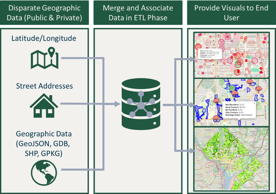
Data Intake and Processing
PALMS can ingest a range of geographic data from highly structured GIS datasets such as GeoJSON or GDB files to text-based street addresses. Our solution can intake this disparate data and create a fully associated dataset. From this information we can create interactive applications allowing users to leverage said data with ease. This provides clients with fully customized GIS applications, capable of leveraging both private corporate data and publicly available geographic data.